Foel Cwmcerwyn Circular
Rating: 5/5
Time: 3h 30m
length: 12.11km
Accessibility: Not wheelchair friendly, but an accessible walk with an easy terrain
0.00km Carpark SN 12770 30824 EAST: 212770 NORTH: 230824

Foel Cwmcerwyn stands high and proud to the far right of the carpark, its steep disused quarry sides hidden in shadow from the sun. We left the back of the carpark via the signposted bridle path. The path was grassy, with a gentle incline to the top of the saddle-shaped ridge. Making sure to keep the steep contour lines of Cairn Siân on our right, we (try) to avoid the boggy streams that occur along the path! We were lucky enough to encounter a herd of beautiful wild
horses, that were eating the heather and grass alongside the path.
1.75km Golden Road SN 12187 32264 EAST: 212187 NORTH: 232263

We reached the ridge and turned left onto the Golden Road. This Neolithic track dates way back to some 5,000 years ago and crosses the length of the Preseli hills, it would have been part of a trading route between Wessex and Ireland- bringing gold from the Wicklow hills. It was well trodden and grassy, much like the earlier path we had just walked. It is VERY boggy in some places, so much so that we found frogspawn! Though it is boggy we had to stick to the path as much as possible, especially in Spring and Summer as it is the ground nesting birds breeding season. As we headed further along, we found small bluestone piles and out-crops littering the sides of the path.
3.71km Foel Feddau SN 10222 32369 EAST: 210222 NORTH: 232368

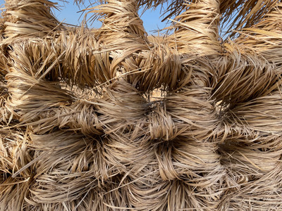
We stopped for food at the top of Foel Feddau, a small cairn sheltered us from the strong wind. The view was magnificent, Newport beach and the sea glistened in the far distance, while behind us, Foel Drygarn stands mighty and proud. After a good lunch and drink of water we set off, branching left to cut off the corner. We came across a fence, and went over the stile, The fence was bazar, its wire squares had caught the long dry grass that had been blown from the field like a net, giving the impression the fence was made entirely from woven hay! We kept on going diagonally, it was fairly steep and tiring, but we finally made to the summit path.
4.87km Final climb SN 09451 31676 EAST: 209451 NORTH: 231676
The summit path was quite flat, with the odd tuft of grass poking out. The wind picked up here, and it got slightly chilly. The views got better and better the higher we went, the valley where we parked looked golden/bronze in the early afternoon sun.
5.37km Foel Cwmcerwyn summit SN 09406 31143 EAST: 209406 NORTH: 231142

The view on top of Foel Cwmcerwyn was breathtakingly beautiful! The houses looked like Lego, from up here. Behind us stood the trigpoint and beside that stood a little pile of stones (possibly a small cairn). As we walked over to the edge (facing the valley) to look down the quarry side, we noticed a circled dip in the earth, presumably (maybe) a small roundhouse, built by a family back in the Bronze/Iron age??? I stopped near the quarry’s edge (to scared to get any closer) and saw the path we took, from the bottom of Cairn Siân in the valley below, to were we stood right now, on top of the world. After some pictures (and another drink of water) we left the summit via the path facing in the
direction of Llys Fran reservoir. Llys Fran poked out from behind another hill, glistening in the sun. The path was steep and slightly slippery in places. We reached the bottom and went through a big metal gate. A forest lay to our right, we followed the path that lay before us, it was well walked with the odd puddle now and again. We made sure to keep the forest on our right-hand side.
6.43km Across the moorland SN 08864 30323 EAST: 208864 NORTH: 230323

We turned off the path after a bit, and head in the direction of the cairn Afr, cutting across the boggy moorland to our left. An old sheep fold was situated to the left of our route, it looked old with moss growing on its crudely shaped stones. Fences began to appear, and flocks of sheep looked at us as we passed. We carried on following the now definite path.
7.63km Join the bridle path SN 09969 29885 EAST: 209968 NORTH: 229885

In the corner of the last sheep field, we went through a gate to join a wide stone bridle path which eventually turned into a grass pathway. As the hedges gradually thinned out, a tinkling stream was revealed which guided us to the road.
8.29km The road SN 09983 29316 EAST: 209982 NORTH: 229316
We turned left to follow the road. Any views were now obscured by high hedges but the tarmack was a welcome change from the soft under foot we had experienced until now.
10.78km Open road SN 11360 306639 EAST: 211360 NORTH: 230639

As the hedges finally came to an end, the road, in turn, opened up to reveal the Preseli's once again. We followed the road across the open landscape until we reached the small carpark in which we had parked that morning.
11.86km Carpark SN 12770 30824 EAST: 212770 NORTH: 230824
As we changed out of our muddy boots, and looked back to the ridge where we had stood a few hours before, the late afternoon's winter sun cast a golden light across the mountains, amplifying their beauty.


Comments